

AUGUST 12, 2015
Groundwater pumping is changing surface levels in the Phoenix valley
The ground level in portions of the metro Phoenix area is dropping by almost an inch a year. The changes will cause problems for canals, public utilities, and building foundations
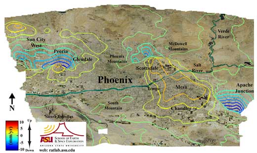
TEMPE – The ground level in portions of the metro Phoenix area is dropping at an annual rate of nearly two centimeters, or almost an inch a year. This is caused by the pumping of groundwater from subsurface aquifers, say two Arizona State University scientists.
Apache Junction, at the east end of the valley, is seeing the fastest drop, followed by Sun City West, Peoria, and the North Valley.
While changes of a few centimeters a year may not seem substantial, when they continue for many years and over long distances they can have serious and expensive impacts. Structures such as the Central Arizona Project (CAP) and other canals, utility lines, water and gas mains, storm drains, and sewers are most affected, while office buildings, apartments and homes can also become damaged as ground levels drop.
"Pumping groundwater alters the elevation of the land surface at different rates around the valley," says ASU researcher Megan Miller. "This happens because the sedimentary basins in the Phoenix metropolitan area vary in thickness and properties."
Miller, a graduate student, and professor Manoochehr Shirzaei, both of the School of Earth and Space Exploration, work with synthetic aperture radar carried on Earth-orbiting spacecraft. Such radar can measure ground elevations to less than an inch over wide areas. By repeating the measurements over time, changes can be detected, tracked and mapped.
The elevation data they used for their study, which has just been published in the Journal of Geophysical Research, come from 1992-1996 and 2003-2010.
"In parts of Chandler, Mesa, and Scottsdale, the ground level has risen in recent years," Miller says. "This is because we are storing the unused part of our water allotment in the ground." But she notes that this cannot be done everywhere, and it cannot undo much of the subsidence that has previously occurred.
"In areas where the land has subsided, the basin layers have become compacted. When water was pumped out, the pore spaces in the aquifers became empty, and the layers settled until the spaces were eliminated," Miller explains.
The water table — the height of the groundwater level — has increased during the period they studied, even where the surface elevation of the land has fallen, says Miller. The continued sinking of the surface is from pumping that occurred years ago.
The demand for water has remained relatively stable during this time, mainly due to the decline of agriculture in the valley. Miller notes, "As more people have moved here, they have settled on land that previously grew crops, which use more water."
Because residential and industrial areas use less water per acre than agriculture, the population increase has been offset by the decrease in agricultural water use. The net result, says Miller, is that demand held fairly steady during the study period, but the source of demand has changed.
"Eventually," Miller says, if current supply and demand trends continue, "We will no longer have a surplus." Then, she explains, "The water table will resume dropping."
Groundwater pumping has two main effects, one short-term, the other long. "The biggest short-term problem is earth fissuring, or cracks that develop and threaten structures and their foundations," says Miller. "Longer term, the changes in surface level can affect where flood waters go, which could produce huge problems for the valley."
A second long-term effect occurs, she adds, when groundwater withdrawals continue: The subsidence reduces the aquifer system's capacity to store water.
"We live in a desert, and our underground canteen is getting smaller."
The School of Earth and Space Exploration is a unit of ASU's College of Liberal Arts and Sciences.
