Town to meet with MCFCD regarding Cave Creek Wash
By Linda Bentley | February 10, 2010
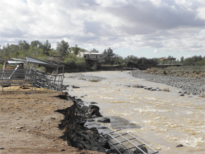 The rain storms in late January caused massive piling of sand, gravel, rock and debris along the western channel of Cave Creek Wash, resulting in a change in water flow and massive erosion along the eastern bank, as pictured here, as well as extensive damage to the Copenhaver family’s home. Photo by Linda Bentley
High flows of long duration from recent storms caused channel shift and bank erosion
CAVE CREEK – On Feb. 3, Town Engineer Wayne Anderson sent a letter to Tim Phillips, chief engineer/general manager, Maricopa County Flood Control (MCFCD) explaining how the rain storms on Jan. 21, 22 and 23 sustained a high flow of up to 13,000 cfs for a long duration in Cave Creek Wash.
The extended high flow resulted in the transport of a large amount of channel deposits along with a shift in the channel to the east for a distance of approximately two miles northeast of the Carefree Highway Bridge.
Anderson stated that channel shift caused massive bank erosion, degradation, damage to properties while endangering numerous homes near Cave Creek Wash.
He requested a meeting with appropriate MCFCD staff to discuss: possible causes of the channel shift, potential for future erosion and property damage, possible preventative measures to protect properties adjacent to Cave Creek Wash, requirements for constructing bank protection, and what type of financial assistance is available for channel stabilization.
On Feb. 8, Stanley Toal, who lives on Creek View Lane, sent a letter to Anderson expressing his neighborhood’s concerns about the uneven deposits of sand, gravel, rock and debris in what has become the two water channels of Cave Creek Wash in the immediate area of their residences and the change in the divided flow ratio between the east and west water courses.
Due to large deposits of material caused by the storm, Toal said the west channel became clogged, which sharply reduced its water-carrying capacity and velocity, resulting in the storm water to “flow in unpredictable and irregular patterns.”
He said, “Ultimately, the east channel became the dominant water course that carried the high-energy, flood-dominated waters during the storm.”
Toal said, “Many of us with frontage onto Cave Creek Wash have lost chunks of the creek bank from the floodwaters being intensified and directed toward our properties,” stating, “This event is more than generational.”
He expressed concerns about what appeared to be the unlawful grading and excavation of the wash within the private Canyon Creek Road alignment and the potential for further downstream deposits. Toal said it could damage properties along the eastern bank while significantly increasing the risk of future erosion and flooding.
Toal also questioned the extent of consultation, if any, Larson Excavating had with town engineers, MCFCD and the U.S. Army Corps of Engineers, which administers Section 404 permits for dredge and fill activities in waterways.
“It is our opinion,” said Toal, “that the sand, gravel and rock deposits should be removed from the water courses and placed along the eastern creek bank for stabilization and to act as a buffer to prevent further erosion.”
Anderson said a meeting has been set up with MCFCD for Feb. 22 and Toal’s concerns would be incorporated into the issues needing to be addressed.